Soaring Above: Providing Unique Insight Into Golf Course Turf Management – Our Talk to the Canadian Golf Superintendents Association Today!
Today our Chief Pilot, Willie Carroll, is speaking at the Canadian Golf Course Superintendents Association annual Golf Course Management Conference in Ottawa.
He’ll be in front of approximately 300 golf course superintendents with a message outlining the opportunities for aerial insight from above for golf course turf management and other issues utilizing drone technology. The golf course industry is one of the fastest growth areas for use of drones, and yet there are many ‘supers’ who aren’t quite clear on what can be done or how this provides such a low cost alternative compared to other, more traditional methods.
LI&D will also be present during the trade show Tuesday – tomorrow – with a booth on the floor, come see us at booth 52.
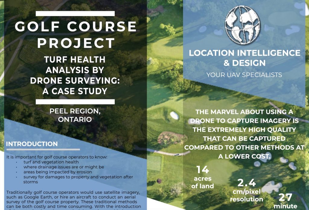
Willie’s presentation will be based upon the detailed case study available on our site that outlines the process involved in a previous course flyover last year. You can read the case study here.
What’s he covering? Here’s the session description!
Drones & Golf: Gaining Detailed Insight From Above
Presenter – Willie Carroll, Location Intelligence & Design
Have you been hearing about new methods of analysis for your golf course using sophisticated mapping tools and want to learn more about it? With advanced drone mapping technology, you now have the chance for extremely complex analysis at a very low cost.
Through identifying vegetation health, stress, and vigour issues before they are seen by the naked eye, drone surveys can help target areas needing more attention throughout the golf season. This could mean more accurate nutrient and fertilizer management with the goal of making resourceful decisions as to how much to apply and where.
Using technology for golf course maintenance is not about making maintenance staff redundant, it is an extra tool to make their efforts more efficient and cost effective. In this presentation, Willie will explain how drones can be incorporated into course maintenance to lend extra data to decision making processes.
Willie shows how drones can be used to provide unique insight for many industries in a very cost effective manner.
In addition to his presentation, LI&D has prepared a very detailed article that provides an overview of the benefits to the golf course industry and course management. Give it a read!

Soaring Above: Providing Unique Insight into Turf Management
Willie Carroll, C.E.T., Location Intelligence and Design
With the fast changing world of technology, drone use within industries has seen a dramatic rise over the last few years. From using drones to monitor hot spots in forest fires to collecting the spray from whales’ blow holes, the capabilities of drones are endless. One area that is up and coming is the use of drones to assist with golf course maintenance, such as monitoring turf and vegetation health, early disease or fungus detection, or identification of underlying drainage issues.
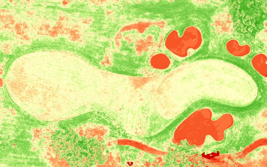
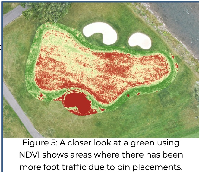
Using a method called the Normalized Difference Vegetation Index (NDVI), turf health can be assessed to identify issues or areas of concern that need to be field checked or monitored. Early detection of possible fungal invasion on greens can be identified so that a treatment can be started before the invasion becomes visible. Most modern golf courses have internal tile drainage under the fairways and greens. Blocked or partially blocked tiles can be detected using NDVI maps by identifying areas of low turf health.
History of NDVI
NDVI was developed by NASA in 1972 as a way to measure the health of vegetation from satellites on a large scale across the planet. The process of NDVI is still used today by capturing imagery in visible and non-visible light wavelengths and has become the standardized method of vegetation health assessment. The most popular use case of NDVI is in agriculture to detect crop health.
What is NDVI
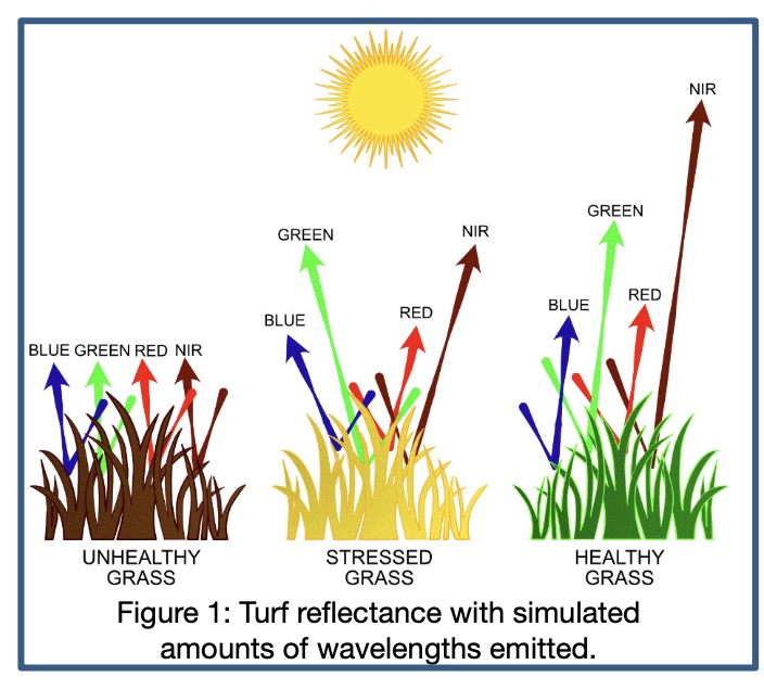
Traditionally, NDVI imagery is captured by satellites for large scale operations. Modern day imagery is now being captured by aircraft and drones which allow for higher quality data for smaller scale operations. NDVI maps are created from the reflectance difference between visible Red Light and non- visible Near Infrared(NIR) Light. Red Light is absorbed by plants for use with photosynthesis while NIR Light is reflected. Green Light is also reflected and is about 5-10 times less intense than NIR Light resulting in the plant’s green appearance to the human eye (See Figure 1). When a plant becomes dehydrated, sick or afflicted with a disease, the spongey layer of the leaf or blade where the chlorophyll is stored, deteriorates and the plant absorbs more NIR Light.
An equation involving the quantity of NIR Light and Red Light is used to calculate NDVI values to create an image where the values change depending on the health of the plant; higher values indicate a healthy plant and lower values indicate an unhealthy plant.
How is the data collected
A drone can fly over a golf course to capture the imagery required to produce an NDVI image. A drone is equipped with two sensors; a standard camera capturing the Red, Blue and Green Light wavelengths, and a specialized sensor that measures the NIR Light reflected from the turf below the drone. As the drone flies over the entire course many photos are taken which are then ‘stitched’ together to make one large image. This image is then analyzed to determine areas within the turf with low health or other areas of concern.
Why collect data using a drone?
Due to their size, drones can be transported quickly and mobilized faster. Other methods take longer: using an aircraft requires more planning and logistics; and satellites have a set return rate, when they orbit over the exact same spot on the Earth, which is usually an average of 24 days. Data can be collected faster and at more frequent intervals by using a drone. This results in updated information throughout the season which the grounds crew can use to manage turf health
The use and benefits of NDVI
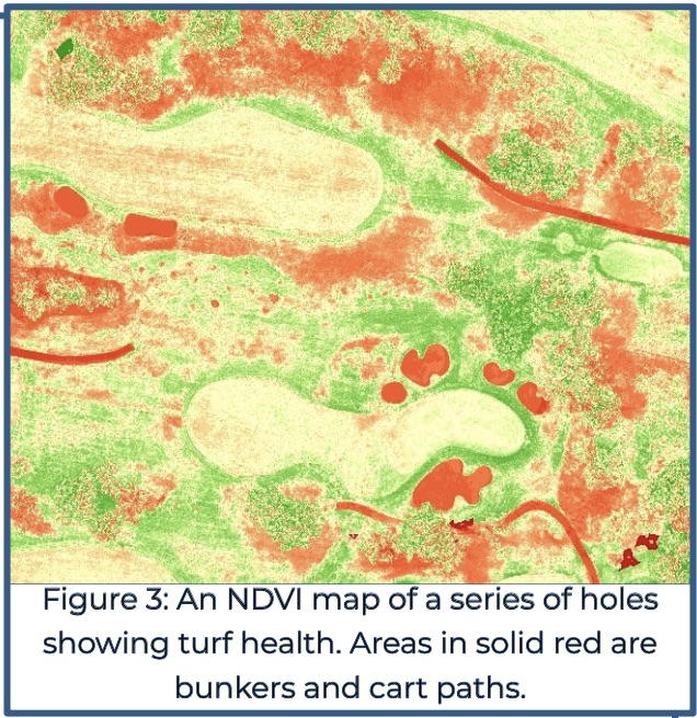
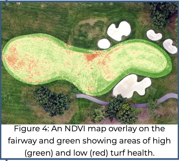
On an NDVI map, green areas or high NDVI values represent healthy plants which require less maintenance. Areas in red or low NDVI values represent
unhealthy plants which would benefit from more care by the grounds crew to improve the quality of the turf (See Figure 3). This will allow for grounds crews to work more efficiently where more maintenance is required, so that they don’t spend time on areas that may not need it. The data is fully GPS-Calibrated so maps can be uploaded to tabletdevices and carried into the field to constantly show your location in respect to any turf management issues that have been identified by the use of NDVI. This allows for maintenance teams to conduct spot checks to ensure that the right areas are being targeted.
By identifying vegetation health and stresses before they are seen by the naked eye, a drone can help target areas needing more attention throughout the golf season. Using drone technology for golf course maintenance does not make maintenance staff redundant, rather it is an extra tool to make their efforts more efficient and cost effective.
If you are in the golf industry, now is the time to start considering how drone technology can assist you with to have faster, better data to use for your maintenance management processes. Give us a call or come visit us at booth 52 to find out how we at LI&D can help you.


Comments are closed.